Romance of Covered Bridges
New Brunswick
Romance of Covered Bridges
New Brunswick
Listen to Karen
 The history of covered bridges in the Maritime provinces is mixed. From the information I researched, there were covered bridges in Nova Scotia. However, it seems the last covered bridge, that crossed the Kennetcook River, was torn down in the late 1960’s.
Prince Edward Island, known for its romantic preservation of lighthouses, is not known for covered bridges. I found a reference to a covered bridge by the Old(grist) Mill in Hunter River, PEI. After visiting it and doing more research, the bridge was built in 2007 and is likely the first covered bridge in PEI. The Old (grist) Mill and bridge were well worth the visit and the link to that blog is here. …………
New Brunswick currently has 58 covered bridges throughout the province. Some are still a viable part of secondary highways, some on back roads which are passable and more snowmobile/ATV trails. Others are preserved on roads which now go nowhere but define the romance of covered bridges that were an important part of road travel in the past.
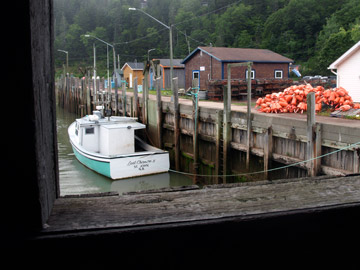
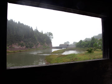 Covered bridges seem to look the same, wooden structures over roads but although similar there are differences and the fun is in the finding and exploring the side roads of New Brunswick. They all have a unique history and quite different locations; some in more populated busier towns while others are located on quiet peaceful back roads of farm country and quiet creeks. Some are short and some have long spans. Some have windows in the side showing interesting views and some have covered pedestrian walkways.
Kings County, home to 16 covered bridges, with 8 of them close to the town of Sussex, the tourist information provides a map which lists the bridges in that area, and we set out to explore and discover them. The map was easy to follow and many were also marked with blue signs on the highways showing where to turn. Some were right off the road and some required more driving along good paved roads and some dirt roads. We managed to visit 11 of them and took some interesting photos.
Covered Bridges in Kings County
Information from http://celebratesussex.tripod.com
Bloomfield Creek, 1917 Length 44.5m (146') Follow Route 121 to Bloomfield, at junction with Route 855. Follow nearby Bloomfield Station Road to bridge.
Centreville, 1911- #5 Millstream River Length 28.9m (95') (3.8-metre-tall clearance, 15-ton capacity) Follow Rte. 10 to Berwick. Turn on to Rte. 880 and follow to Pleasant Ridge Branch Road on your left. Bridge visible at Rte. 880/branch road junction.
Darlings Island, 1914 – beautiful large lake – not in service Built in 1914. Length 41.7m (137') Take Exit 142 from Hwy 1 onto Route 100. Follow to Station Loop Road then turn onto Darlings Island Road. Follow for approximately two miles, until you see the bridge on your left.
MacFarlane, 1909 - #2 Ward’s Creek Length 17.7m (58') (one of two shortest covered bridges in county) From Sussex Corner, follow Rte. 111 (New Line Road) to Upper Wards Creek. Turn right, follow blue signs to covered bridge. After bridge, continue on to Church Avenue, Sussex. Marven, 1903 - #2 Belleisle Creek
Moores Mill, 1923 - #5 Trout Creek Length 17.8m (58' 6") At Waterford, near Poley Mountain. From Rte. 111, turn on to Waterford Road, then onto Drummond Road.
Oldfields 1910 - #5 Smith Creek This is the 2nd most known covered bridge in New Brunswick, appeared on the1992 New Brunswick quarter to mark Canada's 125th anniversary Length 28m (92') (3.7 metres max. clearance, 15-ton load capacity) Follow Rte. 890 13 km from Exit 195 off Rte. 1 at Sussex. Oldfields crossroad will be on your right, with bridge visible from Rte. 890.
Plumweseep, 1910 - #9 Kennebecasis – not in service Length 22.5m (74') (4.2-metre-tall clearance, 15-ton load capacity) Follow Route 890 for 1 km from Exit 195 off Rte. 1 at Sussex. Turn right on to Plumweseep Road, follow to the end. Turn right on to Plumweseep Cross Road and follow to bridge.
Salmon, 1908 - #7.5 Kennebecasis – not in service Length 34.2m (112' 2") Follow Route 890 for 1 km from Exit 195 off Rte. 1 at Sussex. Bridge is on your left.
Smithtown, 1914 - #3 Hammond River Length 55.7m (182' 9") (longest covered bridge in county) On Damascus Road at Smithtown. From Route 100, turn on to Rte. 860. Follow Rte.860 (Lakeside Road) approx. 5km past Hwy 1 overpass before turning right on to Damascus Road. Follow to bridge.
Tranton, 1927 - #1 Smith Creek Length 36.7m (120' 6") (youngest covered bridge in Kings County) (4.2-metre-tall clearance, 15-ton load capacity) Follow Route 890 for 2 km from Exit 195 off Rte. 1 at Sussex. Turn left on to Roachville Road and follow 1 km to bridge.
Urney, 1905 - #4 Smith Creek Length 20.1m (66') At Waterford, near Poley Mountain. Head 12 km east along Rte. 111 from flashing light in Sussex Corner. Turn left on to Urney Road and follow to bridge
Covered Bridges in St. Martins, village on the Bay Of Fundy in Saint John County
The next 2 covered bridges are close together in the beautiful village of St. Martins. According to the website New Brunswick Covered Bridges they are the 2 bridges closest to each other in the province. I got a great photo of one from the other and they are unique in that they both have covered pedestrian walkway as part of their charm.
Vaughan Creek, 1935 - #1 Irish River – not in service Length 21.8m (71' 6") Route 1 Exit 137A-B, Route 111 east for 39.2 km (24.3 mi.) to St. Martins, to Main Street for 2.3 km (1.4 mi.).
Hardscrabble, 1946 - #2 Irish River Length 21.9m (72') Route 1 Exit 137A-B, Route 111 east for 39.2 km (24.3 mi.) to St. Martins, on to Main Street for 2.5 km (1.5 mi.).
Covered Bridges in Westmorland County
These were harder to find as they are not marked on maps as part of tourism marketing and we drove back and forth several times to find at least one of them. But again, part of the fun is finding them and then appreciating the covered bridges for their history and the fact that they have withstood the test of time in surviving. A testimony to the structure and design of the covered bridge. The link below provides a lot of information if you are interested in locating covered bridges in New Brunswick.
Poirier, 1942 - #3 Cocange River Length 41m (136') Route 2, Exit 459A-B, Route 115 north for 15.5 km (9.6 mi.), on to Poirier Office Road for 1.7 km (one mi.).
Budd, 1913 - #5 Cocange River Length 25.3m (83') Route 2, Exit 450, Route 126 north for 6.2 km (3.8 mi.), Indian Mountain Road for 7.4 km (4.6 mi.), on to Victoria Road for 5.7 km (3.5 mi.).
Joshua Gallant, 1935 - #4 Shediac River - not in service Length 25.6m (84') Route 2, Exit 459A-B, Route 115 north for seven km (4.3 mi.), Cape Breton Road for nine km (5.5 mi.), on to Shediac River Road for three km (1.9 mi.), next to north side of highway.
Department of Transportation and Infrastructure, New Brunswick are responsible for maintaining most of the covered bridges (with the exception of 4 which are in Fundy National Park or the City of Moncton) The link above is to their website which lists all the covered bridges by county and their location with photos.
French Village Covered Bridge has been torn down replaced by a modular bridge. It was over 104 years old when severely damaged by an excavator doing work on the deck, discovered the bridge was in worse shape than the government expected.
Click an images below to view photos of Covered Bridges - New Brunswick


About Karen

Karen loves to travel (in comfort) with her husband Gary and "girls" Chessey and Sadie (canines). Karen loves photography and writing so she will be sharing her experiences with you and fellow travelers and giving you a "glimpse" of what it is like to....
"Explore Atlantic Canada" and "Discover all it has to offer".
Photo Credits: Karen